Bartolome Island, Galapagos, Ecuador
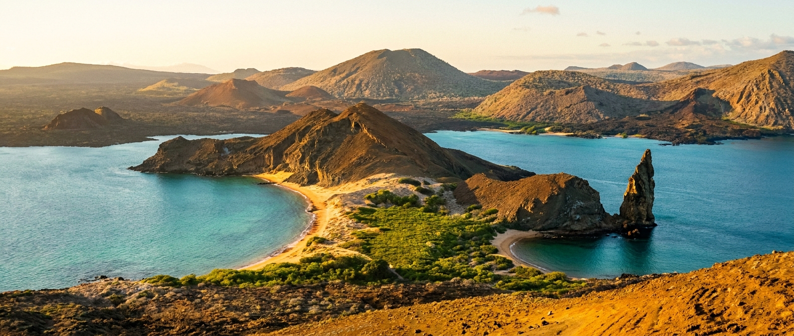
A stark volcanic islet famous for Pinnacle Rock, penguin-filled snorkeling waters, and panoramic views of ten Galapagos islands from a single summit.
A stark volcanic islet famous for Pinnacle Rock, penguin-filled snorkeling waters, and panoramic views of ten Galapagos islands from a single summit.
Ships anchor offshore and transfer guests by panga; there are two separate landing zones for the island's two main visitor sites.
💡 Pro move: Visitor numbers are strictly limited by daily permit caps. All movements ashore stay on marked trails and boardwalks.
There is no pier — all landings are by panga (inflatable dinghy) from anchored vessels.
| Cruise Line | Typical Berth / Arrival | Dock or Tender |
|---|---|---|
| Most cruise lines | Summit trail jetty (dry landing)📍 | Tendered |
| Most cruise lines | North beach / Pinnacle Rock (wet landing)📍 | Tendered |
Bartolome's two visitor zones — the summit trail and the Pinnacle Rock beach — pack an extraordinary amount into a short call.
A 372-step wooden boardwalk climbs to Bartolome's 114m summit for one of the Galapagos's most-photographed panoramas — Pinnacle Rock, Sullivan Bay's lava fields on Santiago, and up to ten islands on a clear day. Moderate effort, 30-45 minutes up.
Find Galapagos summit hike tours →The waters around the iconic volcanic spire are one of the Galapagos's top snorkel sites. Expect Galapagos penguins zipping past, sea lions, green sea turtles, whitetip reef sharks, eagle rays, and a riot of tropical fish.
Find Galapagos snorkeling tours →The golden sand beach at Pinnacle Rock is a nesting site for green sea turtles (January–March). A short mangrove trail leads to the south beach where stingrays and blacktip sharks patrol the shallows — observation only, no swimming.
Find Galapagos beach wildlife tours →Bartolome is one of the Galapagos's younger islands, and the boardwalk trail passes tuff cones, spatter cones, and hardened lava flows up close. A naturalist guide explains the island's formation — a geology lesson unlike any other.
Find Galapagos geology tours →Walking is restricted to two marked routes within the visitor sites — no free roaming is permitted.
From the dry-landing jetty, follow the wooden boardwalk south and up 372 steps to the summit viewpoint. Views of Pinnacle Rock, Santiago's Sullivan Bay lava fields, and multiple distant islands. Return the same way.
🗺️ See full route in Maps →From the north beach wet landing near Pinnacle Rock, a short sandy path through mangroves leads to the southern beach viewpoint. Watch for stingrays and blacktip sharks in the shallows from shore.
📍 Open in MapsClimate normals for Bartolome Island, Galapagos, Ecuador (2014–2023 averages). Pack for the month you sail — highs, lows, and how many rainy days to expect.
| Month | Avg High | Avg Low | Rainy Days |
|---|---|---|---|
| Jan | 83°F / 28°C | 78°F / 26°C | 5 |
| Feb | 82°F / 28°C | 77°F / 25°C | 0 |
| Mar | 82°F / 28°C | 77°F / 25°C | 2 |
| Apr | 83°F / 28°C | 78°F / 26°C | 11 |
| May | 83°F / 28°C | 79°F / 26°C | 27 |
| Jun | 83°F / 28°C | 78°F / 26°C | 28 |
| Jul | 83°F / 28°C | 78°F / 26°C | 29 |
| Aug | 83°F / 28°C | 78°F / 26°C | 29 |
| Sep | 82°F / 28°C | 78°F / 26°C | 29 |
| Oct | 82°F / 28°C | 78°F / 26°C | 29 |
| Nov | 82°F / 28°C | 78°F / 26°C | 27 |
| Dec | 83°F / 28°C | 79°F / 26°C | 17 |
Source: Open-Meteo ERA5 (10-yr daily averages)
Upcoming cruises that call at Bartolome Island, Galapagos, Ecuador. Dates, prices, and ports of call change — always confirm with the cruise line before booking.
Itineraries and prices change — always confirm with the cruise line before booking. Some links are affiliate links that may earn us a commission at no extra cost to you.